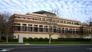
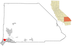
Rancho Cucamonga, California
| City of Rancho Cucamonga | |||
|---|---|---|---|
| — City — | |||
 |
|||
|
|||
| Motto: A World Class Community | |||
 |
|||
| Coordinates: | |||
| Country | |||
| State | |||
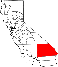
| County | San Bernardino | ||
| Incorporated (city) | November 30, 1977[1] | ||
| Government | |||
| - Type | Council-Manager | ||
| - City Council | Mayor Donald Kurth[2] L. Dennis Michael Rex Gutierrez Sam Spagnolo Diane Williams |
||
| - City Clerk | Janice C. Reynolds | ||
| - City Treasurer | James C. Frost | ||
| - City Manager | Jack Lam | ||
| Area | |||
| - Total | 40.2 sq mi (104.12 km2) | ||
| - Land | 40.19 sq mi (104.09 km2) | ||
| - Water | 0.01 sq mi (0.03 km2) 0.03% | ||
| Elevation | 1,207 ft (368 m) | ||
| Population (2008)[3] | |||
| - Total | 177,736 | ||
| - Density | 4,400/sq mi (1,700/km2) | ||
| Time zone | PST (UTC-8) | ||
| - Summer (DST) | PDT (UTC-7) | ||
| ZIP Code | 91701, 91729, 91730, 91737, 91739[4] | ||
| Area code(s) | 909[5] | ||
| FIPS code | 06-59451 | ||
| GNIS feature ID | 1667908 | ||
| Website | http://www.ci.rancho-cucamonga.ca.us/ | ||
Rancho Cucamonga is a city in San Bernardino County, California, United States. As of the 2000 census, the city had a total population of 127,743, but a 2009 estimate by the state of California put the city's population at 177,736 people.[6]
Dr. Donald J. Kurth was elected as mayor on November 7, 2006. Jack Lam is the city manager.
The city was incorporated in 1977, as a result of a merger among the unincorporated communities of Alta Loma, Cucamonga, and Etiwanda.
Contents |
Geography
Rancho Cucamonga is located at (34.123345, -117.579404),[7] or about 39 miles (63 km) east of Los Angeles.
According to the United States Census Bureau, the city has a total area of 97.0 km² (37.5 mi²). 97.0 km² (37.5 mi²) of it is land and 0.03% is water.
Rancho Cucamonga is the conjunction of the Mojave Trail, the Old Spanish Trail, the Santa Fe Trail, former U.S. Route 66 (now signed as Foothill Boulevard), and El Camino Real.
Demographics
As of the census[8] of 2000, there were 127,743 people, 40,863 households, and 31,832 families residing in the city. The population density was 1,317.0/km² (3,411.4/mi²). There were 42,134 housing units at an average density of 434.4/km² (1,125.2/mi²). The racial makeup of the city was 63.13% White, 13.25% from other races, 8.48% African American, 6.39% Asian, 5.41% from a biracial or multiracial background, 0.72% Native American, and 0.27% Pacific Islanders of the population. Hispanic or Latino of any race made up 27.78% of the population.
There are 40,863 households, of which 44.7% have children under the age of 18. 60.2% of households consist of a married couple living together. 12.8% have a female householder with no husband present. 22.1% were non-families. 16.8% of all households are single-person and 4.1% have a person of 65 years of age or older. The average household size was 3.04 and the average family size was 3.44.
In the city, the population spread is as follows: 29.9% are under the age of 18, 9.9% are from 18 to 24, 33.2% are from 25 to 44, 21.0% are from 45 to 64, and 6.1% are 65 years of age or older. The median age is 32 years. For every 100 females there were 100.1 males. For every 100 females age 18 and over, there were 98.0 males.
The median income for a household in the city was $80,538 and the median income for a family was $88,059.[9] The per capita income for the city was $23,702. About 4.9% of families and 7.1% of the population were below the poverty line, including 7.6% of those under age 18 and 7.3% of those age 65 or over.
The 2008 population estimated by the California Department of Finance was 174,308.[10]
Population history
- 1950 - 1,255*
- 1960 - N/A
- 1970 - 5,796*
- 1980 - 55,250
- 1990 - 101,409
- 2000 - 127,743
(*): Population figures for 1950 and 1970 are for the Cucamonga portion of the city only and the figures were tabulated prior to incorporation in 1977. The 1960 census data was not available.
Source: U.S. Census Bureau
Economy
According to the City's 2008 Comprehensive Annual Financial Report,[11] the top employers in the city are:
| # | Employer | # of employees |
|---|---|---|
| 1 | Chaffey Community College | 1,763 |
| 2 | Etiwanda School District | 1,198 |
| 3 | City of Rancho Cucamonga | 954 |
| 4 | Alta Loma School District | 942 |
| 5 | Amphastar Pharmaceuticals | 880 |
| 6 | Southern California Edison | 800 |
| 7 | Mercury Insurance Company | 606 |
| 8 | West Coast Liquidators | 565 |
| 9 | Frito-Lay, Inc. | 561 |
| 10 | CMC Steel Fabricators | 517 |
Commerce and culture
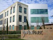
While most of the city's land area is devoted to residential areas, Rancho Cucamonga, like its neighbors Ontario and Fontana, is a major center for the Logistics industry in Southern California. This is due to its proximity to two Interstate Highways and Ontario International Airport, and the space afforded by the large tracts of former agricultural land in the southern section of the city.[12] In the area around Milliken Avenue, between Archibald and Etiwanda Avenues, Foothill Boulevard, and Fourth Street, about seven square miles of land are primarily occupied by numerous massive distribution centers, and even more, smaller manufacturing companies. This area is ringed by wealthy office parks, mostly along Haven Avenue, and shopping strips, such as the Terra Vista Town Center (part of a nearly two-square-mile master-planned community in the center of the city), and malls, such as the Ontario Mills, across Fourth Street in Ontario.[13] The city is also home to Tamco Steel, which runs the only steel mini-mill in California. This mill recycles ferrous scrap, such as junked cars and appliances, to produce rebar.[14]
The city is also the location of The Epicenter, a minor-league baseball stadium, home of the Rancho Cucamonga Quakes. The Quakes' mascot, Tremor, is a "Rallysaurus". A firework show is held after every Saturday game.
Victoria Gardens
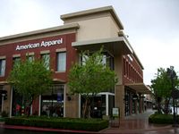
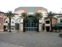
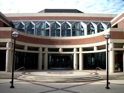
The Victoria Gardens lifestyle center, built in the eastern end of the city, is located at the intersection of Foothill and Day Creek Boulevards. Since the city had never developed a traditional commercial downtown like neighboring cities Ontario and Upland had, special efforts were made in the design of Victoria Gardens in order to bring elements of more traditional and urban town design to what had historically been a decidedly suburban city. While retaining many characteristics of traditional shopping malls, such as large anchor stores, a food court, and sufficiently vast surrounding parking lots and garages, the smaller stores are arranged as city blocks in a grid of two-lane streets, featuring lush landscaping and metered "teaser parking" in front of the stores, which open right up to the sidewalk. There are two "Main Streets", which run from west to east across the center. Running from north to south between them is a pedestrian axis leading from one of the Macy's anchor stores, through a "town square" between a pair of mixed-use office buildings, to the Victoria Gardens Cultural Center, which contains a 570 seat theater and a city library. In addition to the food court, there are restaurants throughout the center, both well-known chains and unique eateries including California Pizza Kitchen, Fleming's, Gyu-Kaku Japanese BBQ Dining, Harry's Pacific Grill, Johnny Rockets, King's Fish House, Lucille's BBQ, P.F. Chang's China Bistro, Richie's Diner, T.G.I. Friday's, and Yard House. The center also features a 12 screen AMC Theatre.[15]
Across the street from Victoria Gardens, Rancho Cucamonga also boasts Southern California's only Bass Pro Shops Outdoor World superstore. Both are highly visible from Interstate 15.
Government
Local government
Rancho Cucamonga is a General Law City, incorporated in 1977 under the "Council-Manager" form of local government. The four-member Council, plus the Mayor, City Clerk, and City Treasurer, are all elected at-large by the voters of the city. The Council then appoints the City Manager, who acts as the aministrative head of the city government, and is responsible for the day-to-day operations, code enforcement, and the fiscal soundness of the municipal government. The council itself serves as a local legislative body.
According to the city’s most recent Comprehensive Annual Financial Report, the city’s various funds had $278.3 million in Revenues, $243.6 million in expenditures, $1,400.7 million in total assets, $492.1 million in total liabilities, and $583.3 million in cash and investments.[11]
The structure of the management and coordination of city services is:[11]
| City department | Director |
|---|---|
| City Manager | Jack Lam |
| Assistant City Manager | Pam Easter |
| Deputy City Manager/Administrative Services | John Gillison |
| Deputy City Manager/Community Development | Vacant |
| City Attorney | James L. Markman |
| Animal Services Director | Joe Pulcinella |
| Building and Safety Official | Trang Huynh |
| Community Services Director | Kevin McArdle |
| City Engineer | Mark Steuer |
| Finance Director | Tamara L. Layne |
| Fire Chief | Mike Bell |
| Library Director | Robert Karatsu |
| Planning Director | James Troyer |
| Police Chief | Joe Cusimano |
| Redevelopment Agency Director | Linda Daniels |
Politics
In the state legislature Rancho Cucamonga is located in the 31st Senate District, represented by Republican Robert Dutton, and in the 63rd Assembly District, represented by Republican Bill Emmerson. Federally, Rancho Cucamonga is located in California's 26th congressional district, which has a Cook PVI of R +4[16] and is represented by Republican David Dreier. In 2005, the non-partisan Bay Area Center for Voting Research ranked Rancho Cucamonga as the 28th most conservative city in the United States.[17]
Rancho Cucamonga is also home to the Foothill Communities San Bernardino County Courthouse.
Infrastructure
Rancho Cucamonga's particular situation at the base of the San Gabriel Mountains has necessitated the use of numerous control channels and basins across the city to reduce the seasonal flood danger from the several streams descending from the range. In past years, some of the city's roads were known for flooding repeatedly. Hermosa Avenue, in particular, now features many high stone curbs and extra-large storm drain grates in order to mitigate the floods.
Utilities
Rancho Cucamonga receives natural gas from the Southern California Gas Company. The city's water supply and sewage are managed by the Cucamonga Valley Water District. Garbage collection is by Burrtec Disposal, phone service is from Verizon, and cable TV is provided by Time Warner Cable and Charter Communications.[18]
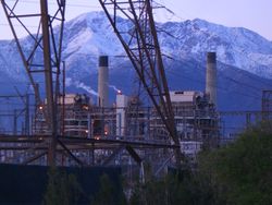
Electric power in Rancho Cucamonga is provided by Southern California Edison, and the city is also home to the Reliant Energy Etiwanda Generating Station, on Etiwanda Avenue. This facility, one of five Reliant stations in California, is a natural gas-fired power plant, which began operation in 1963. At 640 MW net capacity, it is Reliant's second-highest capacity plant on the West Coast. It utilizes four steam turbine generators; of which units three and four are currently active. Steam turbines one and two, as well as a combustion turbine, were retired in 2003 and 2004, respectively. Several systems are in place to control gas emissions, and annually, over 900,000,000 gallons of recycled water are used for cooling.[19][20]
Transportation
Rancho Cucamonga is served by Omnitrans Bus Service, Metrolink Train Service, and nearby Ontario International Airport. Interstate 15 and the relatively new 210 freeway extension run through Rancho Cucamonga as well as the historic U.S. Route 66. I-15 sits atop an elevated berm, and cuts a curve through the southeastern part of the city, isolating a mostly industrial area, a small shopping center, and several housing tracts from the larger part of the city. It then levels out toward the north, and forms part of the northeastern border with neighboring Fontana, before entering the Cajon Pass through the San Gabriel Mountains. Route 210 runs nearly straight east-west through the northern part of the city, roughly bisecting the residential communities of Alta Loma and Etiwanda. The western section of the freeway, as it passes through the city, sits in a trench, but east of Day Creek Boulevard, the freeway levels out, then becomes elevated as it passes the San Sevaine creek flood control basins, before passing into Fontana at the angled interchange with I-15.
Education
Schools
Rancho Cucamonga has multiple public K-12 schools, operating under several different school districts, within its borders: Alta Loma School District, Central School District, Cucamonga School District, Etiwanda School District, and Chaffey Joint Union High School District. In addition to these, Rancho Cucamonga is the home to Chaffey College and satellite campuses of the University of La Verne, University of Redlands, Everest College, and University of Phoenix, as well as the automotive trade school, Universal Technical Institute. Its newest addition is the private school Upland Christian Academy.
High Schools
- Alta Loma High School
- Etiwanda High School
- Los Osos High School
- Rancho Cucamonga High School
Libraries
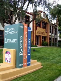
The city of Rancho Cucamonga has two public libraries, with a combined total of over 200,000 volumes. The library at 7368 Archibald Avenue opened in 1994 and was remodeled in the summer of 2008. The Paul A. Biane library at 12505 Cultural Center Drive at the Victoria Gardens Cultural Center opened in August 2006.
The name "Cucamonga"
"Cucamonga" comes from a Tongva place name (perhaps pronounced [kukɑˈmʌŋnɑ]) that probably means "sandy place", although Vera Rocha, Chief of the Shoshone Gabrielino branch, has stated that the meaning is "Place of the villages where the waters come out". Cuc or Kuc = come, come from or come to. Amo = water, wet, spring and Nanga = place of a village. Either interpretation could easily refer to the same place. The northern part of the city is located in the foothills, where there were a number of artesian wells and creeks. The surface soil is extremely sandy and rocky due to repeated storm runoff from the mountains to the north. An alternate theory, that it means "light over the mountain", is almost certainly a fanciful invention, since the "-nga" (or "-ngna") place name ending is found in many other Tongva-derived place names in the region. The area became part of Mexican land grant Rancho Cucamonga, the first non-native use of the name, in the 1800s.
In popular media, "Cucamonga" has been recognized as a funny-sounding place name. One of the catch-phrases of the radio show "The Jack Benny Program" involved a train announcer (Mel Blanc) who said over the loudspeaker, "Train now leaving on track five for Anaheim, Azusa, and Cuc... amonga," taking progressively longer pauses between "Cuc" and "amonga." Part of the joke, for the Los Angeles audience, was that no such train route existed, although all three cities (or at the time, towns) do exist. As a tribute to this 'publicity', the city of Rancho Cucamonga built its minor-league baseball stadium on a street they named Jack Benny Way, and erected a bronze statue of the TV host outside of the building's entrance. The Jack Benny statue has since moved to the Victoria Gardens Cultural Center. (Coincidentally, Jack Benny Way intersects with Rochester Avenue, which is not named for the character portrayed by Eddie Anderson on "The Jack Benny Program", but was named in 1889 after the hometown of three investors, all of whom were brothers from Rochester, New York). In one of his many popular media crossovers, Blanc used that same catch phrase in Daffy Duck's voice in the 1948 Merrie Melodies cartoon "Daffy Duck Slept Here" and later in Bugs Bunny's voice in a 1960s Looney Tunes cartoon.
A California surfing-inspired singing duo, Jan and Dean, appropriated Benny's phrase, writing a song, "The Anaheim, Azusa & Cucamonga Sewing Circle, Book Review And Timing Association" (Liberty 55724), which was the b-side of the successful 45-rpm single, "Ride The Wild Surf", in 1964.
Cucamonga in myth and media
- COPS filmed several episodes in Rancho Cucamonga
- In the movie Next Friday the setting is, and was partly filmed in, Rancho Cucamonga.
- An ABC television movie comedy Camp Cucamonga (1990), presumably takes place in a summer camp in Rancho Cucamonga's forested area in the San Bernardino National Forest. The current city limits barely extend into the forested regions of the foothills, and large parts of Cucamonga Peak north of the city lie in a wilderness area.
- The musical comedy team of Homer and Jethro had a Grammy-winning hit in 1959 with their single "The Battle of Kookamonga", a parody of Johnny Horton's hit "The Battle of New Orleans".
- "Pride of Cucamonga", a wine produced by the Joseph Filippi Winery in Rancho Cucamonga, was used as the title of a song by the Grateful Dead.
- Comedian Jamie Kennedy performed a skit for his hidden camera show The Jamie Kennedy Experiment in which he pranked everyone at the Rancho Cucamonga Quakes Stadium into singing multiple verses of the national anthem.
- In an episode of "The Office", Michael Scott tries to entertain a child during Take Your Daughter to Work Day. Blowing a train whistle, he paraphrases the Jack Benny joke, "next stop Cuc-amonga".
- In the 1995 movie A Kid in King Arthur's Court, King Arthur exiles the villain to Cucamonga at the recommendation of Calvin Fuller.
- Lou Costello (Abbott and Costello) states that he once played with "the Cucamonga Wildcats" during a 1947 performance of "Who's on First?"
- Actor Redd Foxx made frequent references to Rancho Cucamonga in the television show Sanford and Son.
- In the 1960 film version of "The Little Shop of Horrors", there were two teenage girls from "Cucamonga High School", which did not then exist, and is now technically Rancho Cucamonga High School
- In a 2007 Dr. Pepper ad campaign, Rancho Cucamonga was part of a mock weather forecast in which every city was reported to have a temperature of 23, promoting Dr. Pepper's new 23 flavor formula.
See also
- List of people from Rancho Cucamonga, California
References
- ↑ "Incorporation Dates of California Cities". http://www.cacities.org/resource_files/20457.IncorpDateLO.doc. Retrieved 2007-02-20.
- ↑ "Rancho Cucamonga - City Mayor". http://www.ci.rancho-cucamonga.ca.us/govt/mayor_content.htm. Retrieved 2007-02-20.
- ↑ http://dofpublicdev.dof.ca.gov/research/demographic/reports/estimates/e-1_2006-07/
- ↑ "USPS - ZIP Code Lookup - Find a ZIP+ 4 Code By City Results". http://zip4.usps.com/zip4/zcl_1_results.jsp?visited=1&pagenumber=0&state=ca&city=Rancho%20Cucamonga. Retrieved 2007-02-20.
- ↑ "Number Administration System - NPA and City/Town Search Results". http://www.nanpa.com/nas/public/npa_city_query_step2.do?method=displayData&cityToNpaModel.stateAbbr=CA&cityToNpaModel.city=Rancho%20Cucamonga. Retrieved 2007-02-20.
- ↑ http://www.dof.ca.gov/research/demographic/reports/estimates/e-1/2008-09/
- ↑ "US Gazetteer files: 2000 and 1990". United States Census Bureau. 2005-05-03. http://www.census.gov/geo/www/gazetteer/gazette.html. Retrieved 2008-01-31.
- ↑ "American FactFinder". United States Census Bureau. http://factfinder.census.gov. Retrieved 2008-01-31.
- ↑ Rancho Cucamonga 2007 Income Estimates
- ↑ State of California, Department of Finance, E-1 Population Estimates for Cities, Counties and the State with Annual Percent Change — January 1, 2007 and 2008. Sacramento, California, May 2008.
- ↑ 11.0 11.1 11.2 "City of Rancho Cucamonga - Comprehensive Annual Financial Report". City of Rancho Cucamonga. 2008. http://www.ci.rancho-cucamonga.ca.us/pdf/CAFR2008Statistical.pdf. Retrieved 2009-08-13.
- ↑ http://www.citivu.com/rc/city/tlanes.html
- ↑ http://www.cityofrc.us/govt/documents/Exhibit3-1LANDUSE.pdf
- ↑ http://www.tamcosteel.com/compinfo.html
- ↑ http://www.victoriagardensie.com/
- ↑ "Will Gerrymandered Districts Stem the Wave of Voter Unrest?". Campaign Legal Center Blog. http://www.clcblog.org/blog_item-85.html. Retrieved 2007-10-18.
- ↑ Modie, Neil (2005-08-12). "Where have Seattle's lefties gone?". Seattle Post-Intelligencer. http://www.seattlepi.com/local/236320_liberal12.html. Retrieved 2009-09-24.
- ↑ http://www.cityofrc.us/index_res.htm
- ↑ http://www.reliant.com/en_US/Page/Generic/Public/Wholesale_Plant_Listings.jsp#etiwanda
- ↑ http://www.reliant.com/en_US/Page/Generic/Public/Wholesale_Plant_Listings.jsp
External links
- Rancho Cucamonga Redevelopment Agency
- History of Rancho Cucamonga on official city web site
- Rancho Cucamonga Library web site
- The History of Casa de Rancho Cucamonga
- Rancho Cucamonga Chamber of Commerce
- Cucamonga Valley Water District
- City of Rancho Cucamonga
|
|||||||||||||||||||||||||
|
||||||||||||||||||||
|
|||||||||||||||||